Showing posts with label dams. Show all posts

Monday, February 8, 2021

Uttarakhand Floods | A disaster foretold


International geologists and glaciologists studying satellite imagery say the cause of the flooding disaster to be a landslide and not a glacial outburst 

February 09, 2021 / 08:22 AM IST
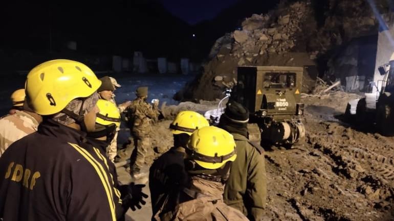
Multiple agencies are working at rescuing over 30 workers feared trapped inside a big tunnel at Tapovan. (Image: PIB in Uttarakhand)

Multiple agencies are working at rescuing over 30 workers feared trapped inside a big tunnel at Tapovan. (Image: PIB in Uttarakhand)

Climate Change? Glacier lake outburst flood? Natural disaster? Manmade calamity? Deforestation? Dams? Roads? Greed? Gods?

The jury is out on what caused the latest Himalayan disaster, when a part of Nandadevi glacier broke off in the Uttarakhand's Chamoli district on February 7 morning, causing massive floods in the Dhauliganga and Rishiganga rivers.

At the time of writing, at least 19 people have been killed, and 150 are missing. The floods also caused major damage to the National Thermal Power Corporation's (NTPC) recently commissioned Tapovan Vishnugad 520 MW hydro-electric project and the under-construction 13.2 MW Rishiganga mini-hydel project, as well as to several homes, roads and at least half a dozen bridges. Most of the missing persons were workers deployed at NTPC's hydropower site.

While media and commentators were quick to attribute the disaster to Climate Change and melting glaciers, specifically GLOFs (glacial lake outburst floods), activists and experts in the Himalayan region have blamed the ecological destruction caused by the unholy rush to build ill-advised dams and roads in this fragile region for the loss of life and property.

Meanwhile, international geologists and glaciologists studying satellite imagery say the cause of the flooding disaster to be a landslide and not a glacial outburst. Dan Shugar of the University of Calgary, who specialises in high altitude glacial and geologic environments, used satellite images from Planet Labs, captured before and after the disaster, and identified a steeply hanging bit of a glacier which likely developed a crack and caused a landslide, triggering an avalanche and the subsequent flooding. Images from the Copernicus Sentinel 2 satellite also showed the formation or opening of a crack in the Nanda Devi glacier that is believed to have triggered the landslide.

The truth is that Uttarakhand's upper reaches, source of several small rivers that feed the Ganga, already has 16 dams, and another 13 are under construction. The Uttarakhand government has proposed another 54 dams on these rivers. On the Dhauliganga River, eight back-to-back new hydel projects are proposed in addition to NTPC's Tapovan project. Blasting of mountains, stone quarrying and digging of tunnels in the fragile mountain system base for the two back-to-back under-construction dams on Rishiganga and Dhauliganga rivers has played havoc with the local ecology.

Incidentally, the Tapovan project started in 2006 and was scheduled to be commissioned in 2013, but the devastating flood in 2013 affected the construction process. Earlier, the project's cost was estimated to be Rs 2,978.5 crore, which was later revised to Rs 5,867.4 crore due to time and cost overruns. The NTPC has already spent more than Rs 4,467 crore on the site.

Although further investigations are required, the fingerprint of Climate Change cannot be ruled out; after all, the India Meteorological Department has recorded January 2021 to be the warmest January in Uttarakhand in six decades.

According to the UN intergovernmental panel on climate change (IPCC), in many high mountain areas, glacier retreat and permafrost thaw are projected to further decrease the stability of slopes, and the number and area of glacier lakes will continue to increase. Floods due to glacier lake outburst or rain-on-snow, landslides and snow avalanches, are projected to occur also in new locations or different seasons.

The Indian Space Research Organisation's resource centre on Himalayan glaciers reveals that glacier melting in the Central Himalayan catchment area, where Chamoli is located, has increased in the first 20 years of this century.

According to the Hindu Kush Himalayan Monitoring and Assessment Programme (HIMAP), co-ordinated by the International Centre for Integrated Mountain Development (ICIMOD), glacier retreat (and some advance) in the face of Climate Change will make the fragile mountains more prone to natural disasters such as landslides, and will make the impact of other natural disasters, such as earthquakes, far greater.

Variations in rainfall will continue to rise, setting in place the possibility of catastrophic flooding. At the same time, springs have been reducing their flows in the hills, which may increase, leading to drought among communities that already have higher-than-national-average rates of poverty.

Ironically, lest we forget, Chamoli, home to Badrinath, Hemkund Sahib, Nandadevi Biosphere reserve and Valley of Flowers, is also the birthplace of the ‘Chipko movement’, and the famous slogan of Sunderalal Bahuguna, “Ecology is the permanent economy.”

We were warned.

Shailendra Yashwant is senior advisor, Climate Action Network South Asia (CANSA). Twitter: @shaibaba. Views are personal. 

First published in Moneycontrol Opinion


Wednesday, May 15, 2019

Red river turns black in North East India


Children crossing the flood-impacted barren paddy fields of North Lakhimpur

Children crossing the flood-impacted barren paddy fields of North Lakhimpur, on Rongali Bihu day

Ranganadi means red river. But the Ranganadi red river of India ran black and turbid on Rongali Bihu, the Assamese New Year’s Day, this April.

The people living along the banks of the river in North Lakhimpur district of Assam could not bathe their livestock in Ranganadi on this special day. Forced to forego a tradition among the Mising tribe to which they belong, residents bathed their cattle and goats in water pumped up from tube wells, ignoring the dangerous level of arsenic in the groundwater.

Red river of India

On February 9 this year, an unprecedented amount of silt and muddy water was released from the Ranganadi dam of North Eastern Electric Power Corporation (NEEPCO)’s 405 MW Ranganadi Hydro Electric Project (RHEP) near Yazali in Arunachal Pradesh.

A major tributary of the Brahmaputra, Ranganadi starts in the Nilam, Marta and Tapo mountain ranges of Arunachal Pradesh, a state in which the river is called Panyor. It is a major source of irrigation water and fish in both Arunachal Pradesh and downstream Assam, where it joins the Brahmaputra.

Shortly after the sudden release of silt by NEEPCO, scores of dead fish of different species and sizes were seen “lying at the bank of the river at Lichi, Upper Sher, Lower Sher, Boda, Upper Jumi and Komasiki village areas,” according to a statement by local NGO Jumi, Komasiki, Cher Green Plus Society (JKCGPS). The NGO has lodged a complaint to the police against the head of RHEP, holding him responsible for the destruction of aquatic lives. It has also threatened to launch a movement.

Bisan Narah showing the high concentration of silt in the red river of India with her hands

Bisan Narah shows the concentration of silt in the Ranganadi water since February

The amount of silt flowing down the Ranganadi seemed unusual even for 74-year-old Bisan Narah of Shantipur village downstream. “Although the dam releases silt from time to time for maintenance, this time the silt and contaminants are really thick in the water.  That Ranganadi dam is like the government’s curse upon our people. In monsoons the floods have worsened because of the dam, in winter the river dries up because of the dam. Our paddy fields are affected by the floods and now there is no fish in the river. The water is unusable for even washing anything.”
Ranganadi dam at Yazali, responsible for turning the red river of India black

Ranganadi dam at Yazali, Arunachal Pradesh

When RHEP became operational in 2001, it was hailed as the first run-of-the-river project in North East India, which would produce electricity without impounding water and displacing people.

But several academics in Assam have since documented that that the channelling of the river’s water through a tunnel on the adjacent hillside has dried up the riverbed the entire length of the channel, effectively stopping the movement of all aquatic life up and down the river, except in the monsoon when the torrential rain common in the area still leads to the river breaking its banks. Guwahati-based environment researcher Mirza Zulfiqur Rahman describes them as “run-away-with-the-river” projects.

As with all hydroelectric projects, RHEP engineers have to get rid of the silt before the water hits the turbine blades – the silt would ruin the blades otherwise. So the water is led to a settlement chamber from which the silt is periodically flushed out and dumped on the riverbed below the dam. It was this dump that was flushed out on February 9 by opening the dam gates. The result is a river that still flows black and turbid.

Women Water Users’ Groups

Women Water Users’ Group of Joinpur Village in a meeting

Women Water Users’ Group of Joinpur Village in a meeting [image by: Shailendra Yashwant]

There are many traditional new year’s day festivities slated for the day, but it is also a holiday, so there is a meeting of the local Women Water Users’ Group (WWUG) convened by the Transboundary Rivers of South Asia (TROSA) programme of the NGO Oxfam in Joinpur village, a stone’s throw from the recently rebuilt embankments that are supposed to protect the village from rising waters of the Ranganadi during the flood season.

Recalling the incidents that led to the current predicament, the women recount how the RHEP was scheduled for complete shutdown for maintenance earlier this year and had indeed communicated the same to the local authorities, who in turn passed on the information to local communities.

Downstream community organisations like JKGPS in Arunachal Pradesh and many other representatives from the WWUGs in Assam demanded that before shutdown NEEPCO must select a site for dumping the silt.

NEEPCO promised a delegation of NGOs that it would not release silt but on the night of February 9,  the state-owned company opened the dam gates releasing massive amounts of silt into the river downstream.

“Did you know that in its shutdown circular, NEEPCO said that it will ‘not take any responsibility for any loss/damage to life and property etc. in case of any accident owing to violation of the notice.’ What kind of company is this, and what kind of government allows them to get away with it?” asked Rachna Padun, President of Joarkhat village WWUG. There were many groups at the meeting.

Barnali Taid sits next to what was her paddy farm and is now a permanent pond due to siltation from floods, near her house in Joinpur

Barnali Taid sits next to what was her paddy farm and is now a permanent pond due to siltation from floods, near her house in Joinpur

“They cannot blame everything on climate change and unpredictable weather. Everyone here knows that the floods are caused by release of excess water during peak monsoon season by the dam. When they do, the water comes with really great force, greater than the normal rise of the river during monsoon. Last year 11 houses in our villages were washed away because the force of water breached the embankments. But no one took any responsibility,” said Barnali Taid , WWUG’s water champion from Jurkha Dambigual village.

After last year’s floods that killed 11 people, the outrage against the dam forced NEEPCO to make a statement, claiming that the situation would have been much worse without the dam. The claim has been contested by scientists and downstream communities alike.

Aruna Das pointing to where the embankment breached during the floods of 2017 in Joinpur, North Lakhimpur, Assam [image by: Shailendra Yashwant]

Aruna Das points out where the embankment breached during the floods of 2017 in Joinpur, North Lakhimpur, Assam

“We haven’t had a chance to rehabilitate our rice farms that are destroyed in successive floods. We seem to be building and rebuilding every year and all the dam does is make some electricity that we will never benefit from,” said Aruna Das, an Aanganwadi (government-run creche) teacher and survivor of the 2017 floods that washed away her house and all their belongings. “We don’t have any factories, so we now grow one crop of rice and a few vegetables. Many farmers have tried pisciculture, but the floods level it all, even the fish farm tanks, year after year. That dam has made our lives impossible.”

“We are supposed to trust these embankments, but they have breached time and time again. The force of water when dam releases it together with the rains is too much for the embankments,” she pointed out.

“What is the point of making electricity, when there is no water to drink or food to eat and when we are living in the constant fear of our houses being washed away?” asked Barnali Taid. “The least they can do is to give us an early warning. Everyone knows that the floods are caused by the dam. The dam authorities should alert us before they release the water, so we have time to react, at least take our children and cattle to higher ground.”

The new embankment on the Ranganadi river near Joinpur

The new embankment on the Ranganadi river near Joinpur

Women seek role in decision making

At the Joinpur meeting, the WWUGs prepared a charter of demands that they wish to present to the district commissioner, with whom they are seeking an appointment to appraise him of their problems.

Clean drinking water tops the list, in a region severely affected by arsenic contamination of groundwater. That is followed by a long list of dam-induced problems for which they seek redressal – clean-up of the river from the ongoing contamination, an early warning system in the flood season, reparations for agricultural and fisheries losses to floods and inclusion of women in dam, floods and embankment maintenance related meetings at the district level.

After more animated talk, the women decided to reiterate the last demand in the introduction. “Women’s water related work is invisible in the current water paradigm though women are primary victims of degradation of nature and water scarcity,” said Gita Rani Bhattacharya, director of the Mahila Samata Society of Assam. “Water entitlements, water technology and infrastructure and voice or decision making in the water related institutions are mostly vested in men.”

“There are hardly any men in the villages, as all the young and able bodied have migrated out for work due to failure of agriculture and fishing here in Lakhimpur. Clearly there is a need to empower women to participate in water related decision-making,” said Vinuthna Patibandla, Oxfam India’s programme officer. “As part of the TROSA programme, we have formed Women Water Users’ Groups in 21 villages. They are an integral part of the village development management committee of the Panchayat, and interacts with district officials on matters relating to water governance.”

While leaving the meeting, Aruna Das asked a question that is on everyone’s mind but rarely expressed. “If these are the difficulties due to one small dam on Ranganadi, what will happen when a much bigger dam, the 2,000-megawatt dam on the Subansiri river, is made operational?”

Barnali Taid is quick to respond, “First let the women take control of this situation. Then we will deal with the big dam.” Everyone giggles at the phrase “take control” as they disperse to resume new year celebrations.


Continue reading the full article.. click here

Tuesday, October 9, 2018

The Kerala Floods: Will The Last Words Ever Spoken Be Why? Why? Why?


"This year, we have seen the terrible flooding in Kerala in India, savage wildfires in California and Canada, and dramatic warming in the Arctic that is affecting weather patterns across the northern hemisphere. The trend is clear. The past 19 years included 18 of the warmest years on record, and greenhouse gas concentrations in the atmosphere continue to rise.” – UN Secretary-General Antonio Guterres.

In August 2018, Kerala experienced once-in-a-lifetime rainfall of 2,378 mm. over 88 days, four times more than normal. The Indian Met Department (IMD) pegged the rainfall in the first  20 days of August at 164 per cent above normal.

Almost all 41 west-flowing rivers originating in the Western Ghats were in spate. The reservoirs of all 82 dams on these rivers were at maximum capacity by August 10, 2018.  Shutters of 54 dams had to be opened by August 21, and the gates of 35 out of these 54 dams were opened for the first time in history.

The rivers already filled to the brims, broke their banks with the release of reservoir water and swept everything in their path – roads, bridges, vehicles, buildings and humans.

The iconic Idukki dam and its reservoir received 811 mm. of rain and when the controversial Muallaperiyar dam began to overflow into the Idukki reservoir, all five gates had to be opened for the first time in 26 years. The resultant trail of destruction from Cheruthoni to Aluva, forced authorities to shut down the Kochi airport. Paddy fields and entire villages in the 900 sq. km. delta of Kuttanad, the backwaters of Vembananad lake, some lying two to three meters below sea level, were completely submerged.

The human casualty was terrible. According to the Kerala government, one-sixth of the total population of the state was directly affected by the floods and its collateral impact. As of September 7, 2018, the death count was 483, with 14 missing. Over a million people were evacuated and are only now, slowly, returning to their homes and their lives.

Continue reading this report on Sanctuary Asia website.

Friday, September 14, 2018

How villagers in Bhutan and India came together to resolve a water-sharing tussle


There are 56 rivers that flow down from the Himalayan kingdom of Bhutan to the eastern state of Assam in India to meet the Brahmaputra River. The hills of Bhutan are covered with lush forests, but on the Indian side of the border there are vast tracts of dry plains with occasional patches of severely denuded forests. Not very long ago the forests were contiguous across the borders but internal migration, poverty and increasing demand for fuelwood changed the landscape drastically on the Indian side of the border.

Due to climate change all the rivers flowing from Bhutan to India have changed their behaviour dramatically in the last decade – with long periods of dryness, shallow flow and then repeated flash floods, followed by massive amount of silt, sand, sediments, stones and boulders hurtling downstream across the border into India, constantly altering the river’s course. This has caused hardships and misery to people on both sides of border.

A large share of Bhutan’s revenue comes from hydropower projects, although it has been declining over the years, from 44.6% in 2001 to 20% in 2013. Most of these hydropower projects have been developed in cooperation with India. Bhutan currently has an installed hydropower capacity of 1,488 MW, although it hopes to increase this to 20,000 MW.

Due to climate change all the rivers flowing from Bhutan to India have changed their behaviour dramatically in the last decade – with long periods of dryness, shallow flow and then repeated flash floods, followed by massive amount of silt, sand, sediments, stones and boulders hurtling downstream across the border into India, constantly altering the river’s course. This has caused hardships and misery to people on both sides of border.

Downstream communities in Assam have regularly raised the alarm, attributing these changes to dam building upstream in Bhutan. They are worried that the plans to build more dams in Bhutan will lead to more flooding, erosion and more destruction than good. The Bhutanese government and their Indian dam consultants have dismissed these objections in the past, but the recent erratic weather patterns have upset all predictions and is now shaping the future flow of the river and Bhutan’s relationship with India.

Read the full report on scroll.in  or on The Third Pole

Monday, August 12, 2013

Brahmaputra and the temples of doom


The boat lurched dangerously. A sudden change in the water current slapped us around for a few minutes, and the river began rising rapidly, unexpectedly. There were no clouds in the sky, no signs of an impending storm, no radio reports of rains upcountry. In fact the weather forecast promised a clear and sunny day in the entire region when we began our journey upriver in the morning.

“These days the Brahmaputra needs no rain, rhyme or reason to swell suddenly like this,” says Jadav Payeng, aka Mulai, a Mishing cowherd now famous as the Forestman of Assam. “As if the deadly floods caused by the monsoon downpour between June and September every year are not enough, since the last few years we have seen floods in the  Brahmaputra, with or without rains -- in summer, monsoon, winter. It is like someone is controlling the water flow but is not very good at it. I am certain the dam-building activity upstream is responsible, either dams in Arunachal Pradesh or Tibet, with Indian or Chinese  control. Whoever is responsible is blind. They don't know what they are doing to the thousands-of-years-old civilisation and still undiscovered biodiversity wealth downstream.”

He exchanges a quick, decisive glance with the other oarsmen and changes the course of the boat to drift back to the northern bank where we will wait on higher land till this bout of unseasonal flood passes. Jadav Payeng has lived on the river all his life; he criss-crosses it every day to go to his home island Aruna Sapori, where he single-handedly planted a 1,360-acre forest over 30 years, now named the Mulai Kathoni after him. He has observed the cycle of floods and erosion of the tempestuous Brahmaputra from close quarters. His forest, like so many others along the river, has been sustained by these seasonal, life-giving floods of the river and its many tributaries.

Continue reading on Infochangeindia

Wednesday, July 31, 2013

Troubled Dibru Saikhowa


Three of India’s eastern-most rivers, Siang, Dibang and Lohit, meet the mighty Brahmaputra river at a unique tri-junction near the borders of upper Assam and Arunachal Pradesh. Located at this confluence, on an island about 12 km. from the tea town of Tinsukia, is the Dibru-Saikhowa National Park and Biosphere Reserve. Spread over 765 sq. km., of which 340 sq. km. form the core of this magical land, this park is a complex of wetlands, grasslands, littoral swamps and semi-evergreen forests, including the largest salix swamp forest in Northeast India.
Walking from Kundaghat to the Balijan forest check post inside the Dibru-Saikhowa National Park on a wet day in April 2013, I spotted Citrine Wagtail, Sultan Tit, Common Stonechat, Indian Roller, Yellow-bellied Prinia, a silhouette of a hornbill that swooped overhead and finally a Jerdon’s Bushchat, a black and white sparrow-sized bird that had not been seen in these parts for over two years. Winter, when the many rivulets and rivers crisscrossing the park have dried up, is the only time when the trek is possible. When the rains pour down, and even for several months after that, access is by boat alone.
In the distance I heard Hoolock gibbons singing their strange songs high up in the canopy of silk cotton, Indian lilac and red cedar trees. I also saw macaques scampering along the branches of a shisham tree and followed a wild hare through my field glasses as it made its way across a clearing in the grassland. Toward the edge of the grassland, a herd of elephants had rested the night before and I could see tell-tale evidence of their fruit-feast from the Outenga (elephant-apple) tree. Around me was a virtual wonderland. I saw willow trees… the ones that make such great cricket bats and hockey sticks. Also what locals call kappofool, the gorgeous pink orchid, in full bloom that heralded the Assamese spring festival of Bihu. 
On the boat back to the mainland, Gangetic river dolphins surfaced near us as they fed from waters that also supported Spot-billed Ducks, herons and an amazing diversity of other waterfowl. In the distance, on the banks of one of the chaporis, I spotted a herd of wild buffaloes retreating into their forest.
Dibru-Saikhowa in spring teems with life of all descriptions, like a virtual showcase of the incredible biodiversity that Northeast India harbours. In my book, Dibru-Saikhowa is up there with Khongchengdzonga and Kaziranga, but as I soon discovered, there is trouble brewing in paradise.
- for full story continue  reading on Sanctuary Asia